Apr 8, 2025
Askja created Iceland’s second deepest lake
Askja is one of Iceland’s most remote volcanic systems hidden deep in the desolate highlands of the Vatnajökull National Park, wrapped in mystery and moon-like landscapes. Due to its location deep in the Northern highlands and relative altitude, it’s highly difficult to access outside the summer months.
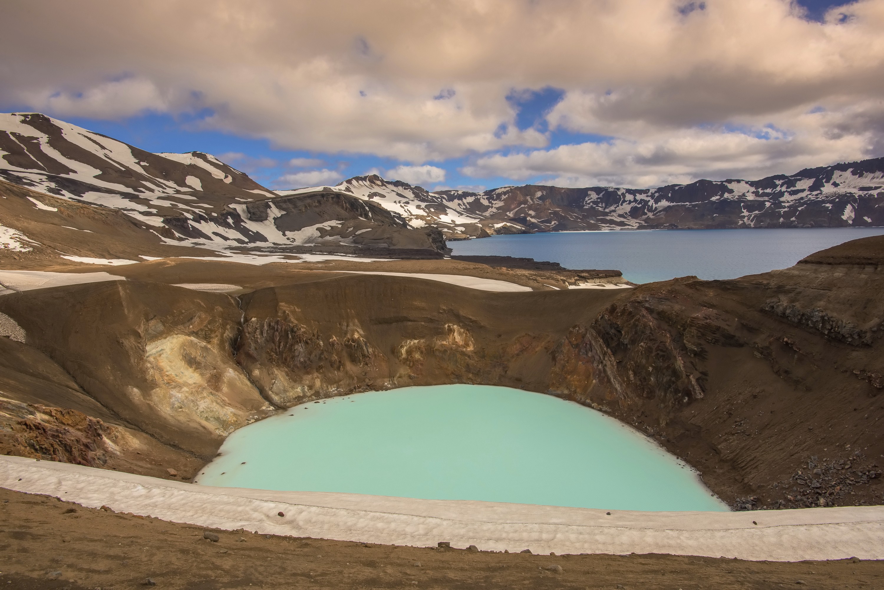
Askja has a long history of eruptions. It last erupted in 1961, but Askja’s most famous eruption was in 1875, when the stratovolcano erupted with a massive explosion that blew the top of the volcano right off. This resulted in a massive cloud of ash and tephra that spread across Iceland and all the way to Scandinavia, triggering a wave of emigration from Iceland. After the 1875 eruption, a large caldera lake formed in the caldera, called Öskjuvatn.
Another smaller crater formed right beside it, filled with warm geothermal water that slightly smells of sulphur and goes by the name Víti, Icelandic for “Hell”. While Askja has been quiet since 1961, clear signs of ground inflation have been detected in recent years, indicating that the magma chamber deep underground is filling up and preparing for the next eruption.
Fun Fact: NASA trained Apollo astronauts at Askja in the 1960s because the Askja surroundings look so much like the Moon!
Geological Facts
Askja is part of the extensive Dyngjufjöll volcanic complex. Askja itself is a stratovolcano accompanied by an intricate network of fissures and craters.
Key geological highlights of Askja volcano
Type: Stratovolcano with an expansive caldera.
Elevation: 1,516 meters (4,974 feet) above sea level.
Caldera: Spanning approximately 50 square kilometers, it features a crater lake called Öskjuvatn, Iceland’s second-deepest lake. Its depth is 220 meters – (722 feet).
Eruption Style: Explosive and effusive, producing pyroclastic material, tephra, and lava flows.
Tectonic Setting: Situated on the divergent boundary of the Eurasian and North American tectonic plates.
Unique Feature: A smaller crater, Víti, formed during a powerful 1875 eruption, is now a geothermal lake popular among visitors.
Prehistoric Eruptions of Askja volcano
Askja’s eruptive history stretches back millennia, shaping the surrounding landscapes with immense lava flows and tephra deposits.
Notable prehistoric eruptions
~10,000 years ago: Lava flows originating from Askja contributed to the formation of the Ódáðahraun lava field, one of Iceland’s largest lava deserts.
~2,500 years ago: Major explosive eruptions deposited widespread tephra layers, which are still visible in Iceland’s stratigraphy.
Recent Askja eruptions
The 1875 eruption of Askja was one of the most significant volcanic events in Icelandic history.
Key details of the 1875 Askja eruption
Timeline: The eruption began in March 1875, with multiple explosive phases.
Ash Cloud: A massive plume of volcanic ash spread across Iceland, with significant deposits reaching as far as Scandinavia.
Global Impact: The ash disrupted agriculture, prompting the emigration of many Icelanders to North America.
Víti Crater Formation: The explosive activity created Víti, a circular geothermal crater. Its depth is about 60 meters (200 feet) and its circumference is about 300 meters (984 feet).
Caldera Lake: Öskjuvatn formed because of subsidence following the eruption, becoming one of Iceland’s most iconic natural features. Öskjuvatn size is 11 KM2 (4.2 mi2). The 1875 eruption had profound environmental, economic, and social consequences.
Timeline of Eruptions
Askja’s eruptive history is marked by events of varying intensity and impact:
1875: Catastrophic explosive eruption, forming the water filled crater of Víti and lake Öskjuvatn.
1921-1929: A series of smaller eruptions produced lava flows near the caldera.
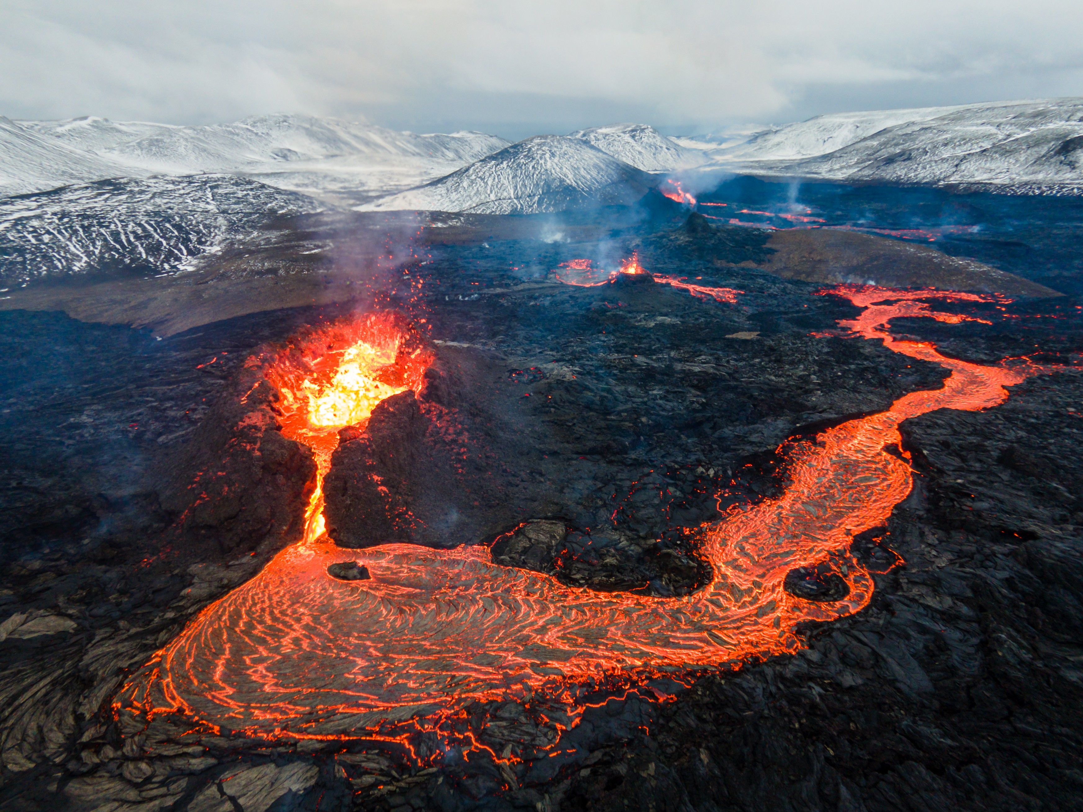
1961: Effusive eruption created a basalt lava field south of Askja, marking its last significant activity.
Impact of Eruptions on Iceland and Its People: Askja’s eruptions have had significant local and national consequences:
Environmental Changes: Volcanic ash from the 1875 eruption disrupted ecosystems and agriculture. Ash and gasses poisoned water supply and killed livestock.
Migration: The devastation caused by the 1875 eruption contributed to a wave of emigration to North America to the United States and Canada.
Askja has reshaped its environment
Lava: The 1961 eruption created extensive basaltic lava flows.
Tephra: The 1875 eruption deposited ash and pumice over vast areas of Iceland and beyond.
Crater Lakes: Öskjuvatn and Víti are striking features created by eruptions in the Askja caldera.
Askja volcano today
Traveling: Today, Askja’s caldera and Víti crater attract adventurers and geologists While Askja has been relatively quiet since 1961, its potential for future eruptions remains a focus of scientific monitoring. Since late summer 2021, Askja has been showing clear signs of unrest, indicating that perhaps, Askja is preparing for its next eruption.
Recent signs of unrest
Ground Uplift: In August 2021, GPS and Satelate data started showing clear signs that the ground around Askja was rising rapidly – a strong signal that magma is accumulating beneath the surface. This inflation has continued since then, with some areas rising over 50 cm.
Temperature Changes: Satellite data also shows rising temperatures in Öskjuvatn (the large caldera lake), possibly linked to geothermal or magmatic activity.
Increased Seismic Activity: While Askja is usually quiet, there has been a noticeable increase in small but consistent earthquakes since 2021 – another sign that magma accumulation in the crust is under increasing pressure
Key risks include:
Seismic Activity: Earthquake swarms in the region may indicate magma movement, and an impending eruption
Ash Clouds: Explosive eruptions could disrupt air travel and impact agriculture, as seen in 1875. Iceland’s monitoring systems use seismic networks, GPS, and satellite imagery to track changes in Askja’s volcanic system.
Askja compared to volcanoes around the world
Askja’s unique characteristics draw comparisons to other well-known volcanoes:
Krakatoa (Indonesia): Both are known for explosive eruptions that had far-reaching atmospheric impacts.
Mount Vesuvius (Italy): Askja’s 1875 eruption mirrors Vesuvius’s capacity for producing destructive ash plumes. Fortunately, Askja is in a remote region of Iceland, with no permanent settlements nearby.
Video: Askja eruption in 1961